
Last night I attended the Outdoor Safety Lecture.
It's required if you want to take hikes or walks
outside of town on the fairly extensive (at least
for Antarctic standards) Ross Island Trail System.
The Ross Island Trail System is a new name for a
series of trails in the McMurdo area that includes
the Castle Rock Loop, Cape Armitage Trail, Hut Point
Trail, Observation Hill trail and others. I think
they finally got smart by giving the trail system a
logo, very similar to those used by the Appalachian
and Pacific Crest Trails. It also sets up some
unique marketing opportunities for the store here.
They'll be able to sell clothing, stickers and patches
with the logo on them.
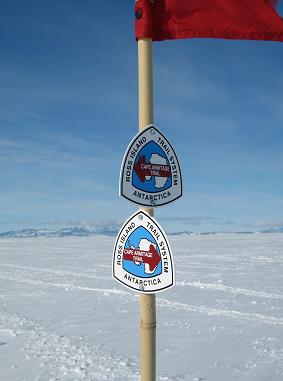
This logo is also used on directional signs. In this
picture, you can see it being used on the Cape Armitage
Trail. It's really important to stay on the flagged
routes here as there are crevices everywhere. All are
marked ahead of time by black flags, but sometimes not
so bright people stray off the trail and fall in, through
these huge cracks in the ice that can be dozens of feet
deep. Sometimes they are saved, and sometimes they aren't.
I remember back in 2001, I went to Sea Ice training school
and we learned how to avoid crevices (prounounced Cruh-Vasses).
I got a little bit of a scare on the same trip when crossing
a tiny crevice (we knew it was there and were told to walk
over it). It was only a couple of feet deep and was in the
transition ice between Tent Island and the Ross Ice Shelf.
Transition Ice is formed when ice pushes up against a land
mass. There is lots of transition ice near McMurdo and
Scott Base. Anyway, I miss-stepped and one foot went in
and the other stayed out. As a result, I had one leg
straight out across the top of the ice and the other straight
down. It was awkward, but I climbed out and gave a big
sigh of relief. Crevices, even small, are nothing to mess
with.
Getting back to the Outdoor Safety Lecture, it was
entertaining because our friend, Mary, was the instructor.
Otherwise, the information was similar to last year's
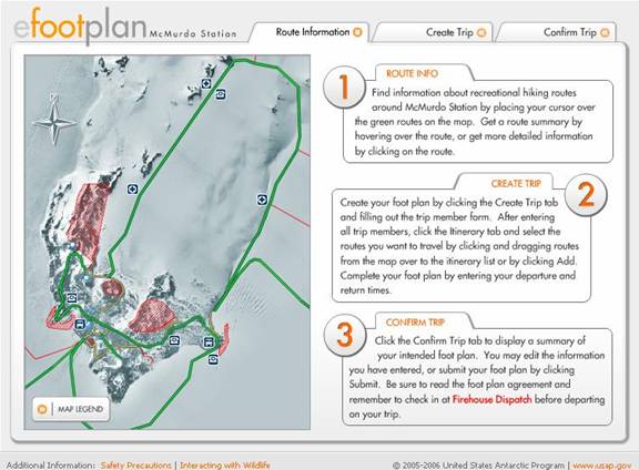
lecture. USAP has gotten into the age of user-friendly
websites though as they have developed something called
the eFoot Plan. This allows you to set up your hiking
plans online and file your plan with the Firehouse. All
hikes outside of town must be filed with the Firehouse and
a radio must be taken. If you don't show up at the time
you say you will, they send out the SAR team, including
helicopters in the Summer. That's great if you're actually
lost or stranded, but not if you're back in your dorm room
and forgot to check in upon returning. The eFoot plan
also includes some really great interactive maps, directions
and tips for having a good hike. Even though I'm going to
be really busy this summer, I hope to get a couple nice
hikes in, especially now that they've made it a lot easier
to file your plan. Now if they could only make the hiking
easier.
2 comments:
Computers are SO AMAZING! Are there programs that will plan out hikes at other places or is this unique to Antarctica? Hope you're adjusting to the night/day changes. It would actually be ideal for me since I love to stay up all night and hate mornings.
I think there are other websites like this as I've seen this type of interactive stuff before. I guess it would just take some looking on Google. Adjusting is going well, although I just had a day off yesterday and it's really tempting to go to sleep when everyone else does.
Post a Comment